South Yorkshire Geology
Recording, conserving and promoting the landscape and rocks of the Sheffield region
An outline of the geology of South Yorkshire
Although confined by surrounding land in the Midlands and the north of England, the Pennine Basin was connected to the nearest ocean and the water level within the basin fluctuated in response to repeated changes in global sea level. These marine oscillations were the result of successive phases of ice-advance and ice-retreat associated with a major glaciation event taking place in Gondwanaland, in the southern hemisphere.
The regional landscape at that time would have been a broad coastal plain of low relief, with the coastline regularly moving across the area and back again as the relative sea level rose and fell. Each marine flooding event is usually recognised as a thin layer of dark shale in the sedimentary record containing characteristic fossils (called "marine bands". Successive marine bands are distinguishable because the animals which formed these fossils were evolving and their preserved remains show subtle progressive changes. Each time the sea level lowered again, the shallow sea floor exposed by the retreating coastline was reclaimed by rivers and colonised by dense vegetation. Thick accumulations of dead trees and other plant matter, after burial beneath further layers of sediment, were compressed into seams of coal. Continual subsidence enabled the basin to accumulate a substantial thickness of sedimentary layers (maximum of 2.5 km) until it was eventually "inverted" during the waning stages of the collision (the Variscan Orogeny), i.e., the layers of sediment were partly "squeezed-up" and gently deformed by folding and faulting.
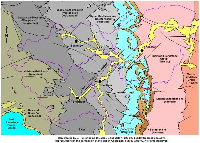
During the Permian Period the uplifted mass of Carboniferous strata from the inverted Pennine Basin was gradually reduced in elevation by erosion. Continental stretching opened a new connection to the oceans, causing low-lying areas to flood again with a shallow, hypersaline sea. A thick layer of dolomitic limestone deposited from this sea overlies the Carboniferous strata with a distinct unconformity and its eroded margin forms a prominent escarpment in the eastern part of South Yorkshire. Some of the dolomite beds contain fossilised reefs formed from communities of corals and shells.
There are no strata preserved in South Yorkshire from younger geological periods, i.e., the Jurassic, Cretaceous and the Palaeogene. Such deposits may have existed but were removed by erosion associated with gentle regional uplift during the continental collision which created the Alps (the Alpine Orogeny). During the Quaternary Period (the last 2 million years), South Yorkshire was partly covered or affected by advancing and melting ice, possible several times, although the most recent ice event tended to remove unequivocal evidence of previous ones. Most of the combined Sheffield, Rotherham and Barnsley district was unglaciated during the last ice age (the Devensian), although large parts of the area included within the Doncaster Metropolitan Borough were covered at times by the ice-dammed meltwater of Glacial Lake Humber and an ice-marginal moraine also occurs near the eastern boundary of the borough.
The fascinating geological history of South Yorkshire can be interpreted from a detailed examination of rock strata, superficial deposits and landforms. Evidence from rock outcrops can be used to understand the sedimentary depositional environments of the Pennine Basin, to map the flow direction and likely source of paleo-rivers and the extent of the marine flooding events, to investigate the evolution of life-forms during that time (both plant and animal) and to observe the deformation resulting from the basinal inversion. Some of the regional geological sites are recognised as internationally important type-localities for specific geo-chronological markers, and local names have been incorporated into the standard stratigraphical nomenclature (e.g., Langsettian from Langsett, Bolsovian from Bolsover and Duckmantian from Duckmanton).
The geology of South Yorkshire has played a very important role in the human history of the region, particularly during the industrial revolution of the 18th and 19th centuries, when coal, ironstone, fireclay, ganister, shale and sandstone were extracted from the sedimentary layers of the Pennine Basin in large quantities to support a rapidly-developing economy. The interpretation of geological sites at the ground surface in South Yorkshire today is greatly enhanced by the availability of information recorded from underground mine workings. This additional information enables a 3-dimensional understanding of many regional geological features of which only a minor part may be visible at outcrop and most is hidden from view.
