Kinderscoutian
Recording, conserving and promoting the landscape and rocks of the Sheffield region
Kinderscoutian Substage
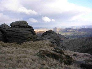
Fig. 1: Tors in the Kinderscout Grit above Grindsbrook, Edale
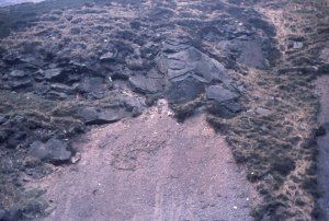
Fig. 2: The erosive base of the Shale Grit with a deep infilled channel, Grindsbrook valley, above Edale village
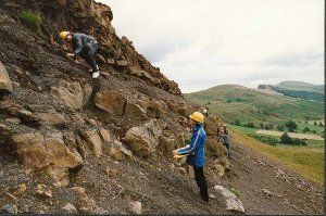
Fig. 3: Investigating palaeocurrent directions at Mam Tor
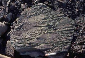
Fig. 4: Sole marks (flute casts, groove casts and prod marks) at Mam Tor
Kinderscout Grit
(up to 140 m thick)
As the name suggests, the resistant sandstones of the Kinderscout Grit form the Kinderscout Plateau. The base is unconformable on the mudstones of the top of the Shale Grit, and in Edale itself these are distinct enough to be given their own name - the Grindslow Shales.
The Kinderscout Grit is dominated by medium- to very-coarse grained, cross-bedded sandstones. It has a relatively high content of feldspar and frequently contains layers of rounded pebbles. Beds of shales and siltstones also occur. The coarse sandstones have weathered to produce tor formations at the edge of the Kinderscout Plateau, reminiscent of the better-known granite tors of Dartmoor (Fig. 1). Further east, it is more uniformly medium-grained and it is still being worked for freestone at Stoke Hall Quarry near Grindleford.
The top of this unit is taken as the passage into the Bilinguites gracilis
Marine Band. The Kinderscout Grit is regarded as a delta-top deposit, with the Pennine Delta now having reached the South Pennines, i.e. it is largely a fluviatile deposit. As might be expected, marine bands now became less common, and depended on sporadic rises in sea level flooding the deltaic surfaces.
Shale Grit
(up to 200 m thick)
The Shale Grit is well-exposed in the Edale Valley and demonstrates a strongly erosive base into the underlying Mam Tor Beds, with deep channels, formed by strong underwater currents (Fig. 2). This rather contradictory name reflects the nature of the formation of which it is composed, i.e. layers of dark shales, alternating with thick medium- to coarse-grained sandstone units.
The Shale Grit is interpreted as forming on the front slopes of the advancing Pennine Delta, which by now was the dominant feature of the South Pennine region, i.e. proximal turbidite deposits. The Shale Grit is the first of the Namurian rocks to crop out in our area, along its western edge.
Mam Tor Beds
(up to 135 m thick)
The Mam Tor Beds are the first rocks of the Kinderscoutian Substage, and as the name suggests, have their type locality in the landslide scar of Mam Tor, near Castleton (Fig. 3).
The base is defined at the first sandstone unit above the Reticuloceras reticulatum
Marine Band. The sequence consists of multiple turbidite sediments, where each unit of micaceous sandstone starts with an erosive base into siltstones beneath, often with sole marks (Fig. 4). Rip-up clasts are common in the sandstone units. Each unit then fines upwards to finish with siltstones or shales.
Measurements of sole marks (groove casts, flute casts and prod marks) at Mam Tor show palaeocurrent directions flowing predominantly from the north or north east. The Mam Tor Beds are interpreted as being delta-front deposits, brought down in pulses into deeper sea water by repeated turbidity currents, i.e. distal turbidite deposits.
