Carboniferous
Recording, conserving and promoting the landscape and rocks of the Sheffield region
Carboniferous System
Rocks of Carboniferous age underlie most of the landscape forming the Peak District and the Sheffield region. They were deposited in a low-lying, paralic sedimentary basin centred over what is now central England and constrained by surrounding continental landmasses and mountain ranges, but with connections to a distant sea. The basin developed towards the closing stages of the Variscan Orogeny when the Armorican tectonic plate collided with southern Britain and other areas of northern Europe. In the Pennine Basin the early Carboniferous strata (late Tournaisian and Visean Stages, 360-326 Ma) are characterised by shallow water marine limestones, with disconformities between limestone units resulting from intervals of lower relative sea level when the shallow sea floor temporarily became dry land. During the late Carboniferous Period (Namurian and Westphalian Stages, 326-306 Ma) the marine basin gradually became infilled with clastic sediment and the coastline migrated away from the Sheffield region. Continued gentle land subsidence allowed a thick succession of mudstones, siltstones and sandstones to accumulate in a predominantly non-marine environment.
Later earth movements have uplifted and eroded away part of the Carboniferous strata, revealing the convenient stratigraphical cross-section we see at the land surface today. Magnetic evidence preserved in some of the rocks shows that, at that time, the region lay in equatorial latitudes. This is consistent with the character of the fossils - both plant and animal species - occurring in the strata.
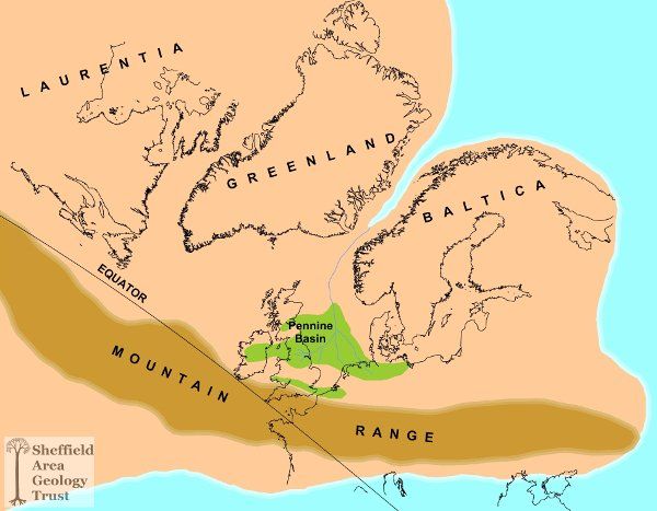
Figure 1. Simplified palaeogeographical map showing the location and setting of the Pennine Basin within the Laurentian continent during late Carboniferous time (c310 Ma ago). Approximate positions of present-day shorelines are shown.

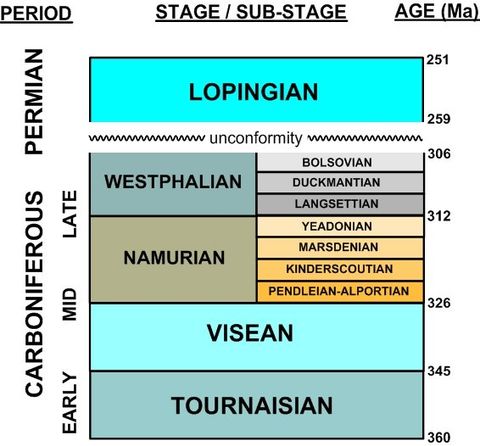
Figure 2. Simplified geological time chart for strata exposed in the South Yorkshire area (not drawn to scale. Sub-stages for Tournaisian and Visean omitted). Adapted from:
Stratigraphical Chart of the United Kingdom: Southern Britain.
Waters C. N. et al, 2007. British Geological Survey.
Early Carboniferous - Tournaisian and Visean
A series of light- to dark-coloured limestones, some containing nodular chert and thin intercalations of calcareous mudstone, was deposited during the mid Tournaisian to latest Visean in an equatorial marine environment. The lighter-coloured limestones were deposited in thick beds on extensive shallow marine 'shelf' areas fringed and protected by peripheral algal reef mounds. They contain abundant fossils of marine shells and corals. Thinly-bedded dark limestones and mudstone accumulated in the surrounding areas of deeper water.
The sediments show evidence of cyclic sea level changes associated with oscillations in the extent of the ice sheet covering the South Pole and adjacent parts of the southern hemisphere (often called cyclothems'). Palaeo-karstic surfaces (potholed, with thin fossil soils) preserved within the shelf limestones provide evidence of non-deposition associated with lower relative sea levels. Volcanic tuffs and basaltic lavas interbedded with the limestones indicate that sporadic volcanism also occurred during this time. The early Carboniferous rocks of late Tournaisian and Visean age crop out in the area of the White Peak but are not exposed at the surface in South Yorkshire. They are present in this area at depth however, and also beneath other parts of the East Pennine Basin, as confirmed by deep borehole drilling and geophysical surveys.
Late Carboniferous - Namurian and Westphalian
The late Carboniferous succession was deposited as a very thick (approximately 3 km) series of dark grey mudstones and siltstones with a number of prominent sandstone units. It comprises a single, more or less continuous sedimentary sequence. The lower part of the sequence was deposited in a fluvio-deltaic-marine environment, while in the higher parts of the succession lacustrine and fluvial sediments predominate, as the coastline migrated away from the Sheffield area in response to continued lowering of the relative sea level. This change in regional depositional environment is evidenced by differences in the character of the sandstones and the increased frequency of coals towards the top of the sequence. Because of the economic significance of the thicker coals in the uppermost part, the stratigraphy has been subdivided and the younger Pennine Coal Measures Group is distinguished from the older Millstone Grit Group beneath. The Pot Clay Marine Band, which overlies the highest (youngest) of the coarse-grained sandstones, is the horizon selected as the boundary separating the two stratigraphical groups.
Periodic marine flooding events associated with sudden and brief increases in relative sea level are recorded in the stratigraphical succession in the form of thin beds of dark mudstone. Referred to as 'marine bands' , they contain a distinct assemblage of salt-water macrofossils. Fossil goniatite species within the marine bands are important markers for correlation across the Pennine Basin and beyond, and also for understanding the regional stratigraphy in terms of chronological stages.
The Craven Group is dominated by mudstones of the Bowland Shale Formation (previously called the Edale Shales in this area, of Pendleian age), followed by the Millstone Grit Group which is comprised of alternating thick mudstone and fluvio-deltaic sandstone units showing both cross-bedded and turbiditic fabrics. This Group underlies much of the Dark Peak area. A similar sequence of mudstones with fewer and more channel-like sandstone bodies continues into the Pennine Coal Measures, accompanied by an increase in the frequency of coals. Changes in climate and depositional environment can be deduced from the sedimentology. These sediments contain fossils of plants and fresh-water molluscs and fishes. Coal seams are the preserved remains of thick layers of peat and lycopsid forests which grew in swampy, floodplain environments adjacent to major river channels and shallow, ephemeral lakes. Thin coal beds in the lower part of the Lower Pennine Coal Measures are often associated with seatearths, i.e. ganisters and fireclays, both of which were used to manufacture refractory materials for the local iron and steel industries.
Coal Measures sandstone beds have been exploited throughout South Yorkshire for millstones, grinding stones, flagstones and for building stone. The Middle Pennine Coal Measures include most of the thicker coal seams that have been worked by underground mining methods. The mudstones and siltstones have been used extensively for brick making and specific mudstone beds containing abundant concentrations of clayey-siderite nodules were mined for low-grade iron ore.
In the Upper Pennine Coal Measures the coals are mostly thin and marine bands infrequent as the depositional environment became increasingly fluvial and terrestrial. The exposed Carboniferous sequence is terminated by the erosive, unconformable base of the late Permian strata, representing a gap in sedimentary deposition equivalent to approximately 45 Ma of geological time.
